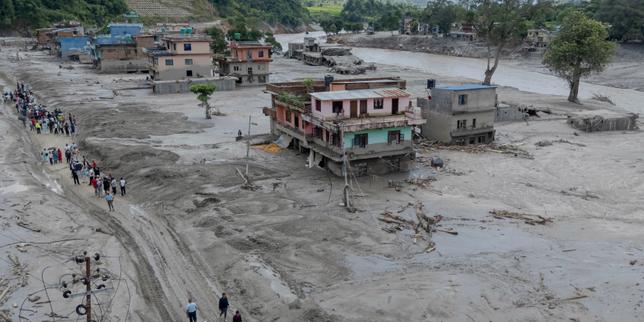
On August 26, 2026, a massive wall of gray-brown water, ice, and sediment obliterated parts of Nepal and Tibet in minutes. This wasn't your standard seasonal monsoon overflow. It was a terrifying multi-hazard cascade kicked off by the partial collapse of a mountain glacier high up on the Langtang Lirung peak.
If you've only seen the headline-grabbing CCTV footage of the Gyirong border crossing getting wiped out, you're missing the terrifying mechanics of how high-altitude cryosphere disasters actually happen. Let's break down what triggered the catastrophe, why early reports got it completely wrong, and what this means for the future of Himalayan communities. Meanwhile, you can find other stories here: Why Geologists Were Wrong About Gondwana And The Hidden Crust That Changes Everything.
What Actually Happened on August 26
At roughly 5.2 kilometers above sea level, a 0.2-square-kilometer block of ice and rock detached from the mountain slope. It didn't just slide gently; it dropped vertically about 1.2 kilometers straight down into the valley below.
This titanic avalanche of 55 million tons of rock and ice generated a seismic shockwave that registered as a magnitude 5.2 tremor. That initial reading fooled initial responders into thinking an earthquake had struck the region. In reality, the earth shook because of the heavy impact, not the other way around. To see the full picture, check out the excellent report by USA Today.
The debris slammed into the Lhende Khola and Trishuli river gorges, creating a temporary dam that breached within minutes. What followed was a catastrophic flash flood. The surge swelled rivers by at least 230 feet in narrow gorges and spiked water levels by 30 feet in just 30 minutes downstream. Whole villages vanished. Vital hydroelectric plants were smashed. The human cost has climbed past 1,300 confirmed deaths, with thousands still missing across the rugged borderlands.
Why the Early Explanations Were Wrong
When disaster strikes fast, misinformation travels faster. Initial news flashes blamed a classic glacial lake outburst flood, or GLOF. Others pointed the finger at tectonic fault lines.
Satellite imagery reviewed by geologists like Daniel Shugar quickly disproved those theories. There was no pre-existing glacial lake that burst its banks. Instead, scientists discovered that the glacier north of Langtang Lirung had been accelerating its movement for weeks, sliding roughly 10 millimeters per month between January and August 2026.
The lower tongue of the glacier had retreated significantly over previous decades, leaving the ice hanging precariously on a steep slope. When the supporting bedrock and frozen permafrost broke down under warming temperatures, gravity took over with devastating velocity.
The Flaws in Modern Early Warning Systems
You'd think high-risk mountain corridors would have bulletproof alert systems by now. They don't.
Nepal and Tibet rely heavily on water level monitors designed for traditional monsoon floods or seasonal runoff. Those systems failed completely on August 26. The flash flood moved too fast, and the upstream monitors were literally smashed to pieces by the initial wave before they could transmit any warning data to downstream communities.
When a wall of water travels 60 miles down steep gorges at highway speeds, standard text-message emergency alerts are useless. Governments are now forced to rethink how they monitor high-altitude permafrost and retreating glaciers before more valleys are caught completely off guard.
What Comes Next for the Region
The devastation spans far beyond broken infrastructure and lost homes. Critical trade routes like the Gyirong Port are crippled, and regional energy grids have lost multiple hydroelectric stations.
International agencies and local governments are currently scrambling to raise emergency funds for displaced survivors, clean water restoration, and mobile healthcare units. Yet, funding is falling short of what is desperately needed on the ground.
Mountain communities are paying the highest price for environmental shifts they did little to cause. If you want to support recovery efforts or track ongoing humanitarian appeals, look directly to established relief programs operating in the Rasuwa and Nuwakot districts. Stop ignoring the vulnerability of the roof of the world. The next collapse is already in motion.